You are here
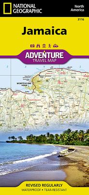
Back to topJamaica Map (National Geographic Adventure Map #3116) (Folded)
Description
- Waterproof - Tear-Resistant - Travel Map
National Geographic's Jamaica Adventure Map is designed to meet the needs of adventure travelers with its detailed and accurate information. This map includes the locations of cities and towns with a user-friendly index, a clearly marked road network complete with distances and designations for roads/highways, plus secondary routes for those seeking to explore off the beaten path. Adventure Maps differ from a traditional road map because of the specialty content they include. Each map contains hundreds of diverse and unique recreational, ecological, cultural, and historic destinations -- outside of the major tourist hubs. National Geographic Adventure Maps are the perfect companion to a guidebook.
The Jamaica Adventure Map covers the entire island nation in one easy to use map. The east side of the map includes the capital city of Kingston, Blue Mountains - John Crow National Park as well as Morant Point on the eastern edge of Jamaica. The west side of the map includes the famous tourist destinations of Montego Bay and Negril with its miles of uninterrupted white-sand beaches. The map also shows the many offshore reefs that ring this Caribbean nation.
Every Adventure Map is printed on durable synthetic paper, making them waterproof, tear-resistant and tough -- capable of withstanding the rigors of international travel.
Map Scale = 1:150,000Sheet Size = 25.5" x 37.75"Folded Size = 4.25" x 9.25"